The Crisis:
Coastal Louisiana land loss rates highest in the world at a rate of 30-50km2 per year lost over the last two decades, according to a 2017 U.S. Geological Survey report.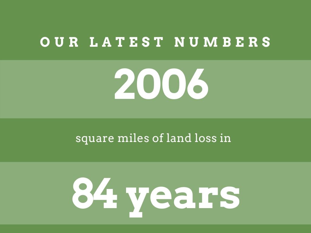
This report also states Louisiana coastal parishes have lost 2,006 square miles (5,197 square kilometers) of land from 1932 to 2016. That’s about 25 percent of the wetland area that was present in 1932, and equivalent to the size of Delaware.
Couvillion et al also state all basins, with the exception of Atchafalaya Delta Basin, have experienced a net decrease in wetland area during the period of observation (1932–2016).
In terms of total area, Terrebonne Basin has experienced the greatest decrease in wetland area (-1,302 km2 observed; -1,352 +/- 136 km2 modeled), followed by Barataria Basin (-1,120 km2 observed; -1,177 +/- 106 km2
modeled).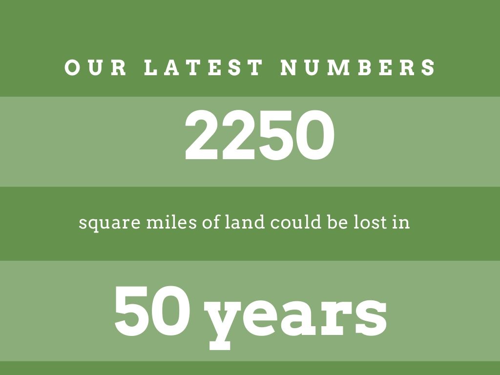
According to the 2017 USGS report, this equates to long-term average loss rates of approximately an American football field’s worth of coastal wetlands within 34 minutes when losses are rapid to within 100 minutes at more recent, slower rates.
Louisiana loses the equivalent of land mass of New York City every 13 years or 31 Washington DCs since 1930.
According to Louisiana’s Coastal Master Plan, without future action, 2,250 additional square miles of Louisiana are at risk in the next 50 years.
This equates to over $150 Billion in anticipated flood damages.
LA contains approximately 40% of the nation’s wetlands and experiences 90% of the coastal wetland loss in the lower 48 states.
Louisiana: Facts and National Impacts
Over the past 7500 years, the Mississippi River has switched back and forth, depositing sediment to create deltaic lobes often to abandon those lobes to create a new one when it changing course.
Starting around 7500 years ago, (5000 B.C.) the footprint of Louisiana did not yet exist.
Within the last 1,000 years or so ago, the lower Mississippi switched to its current course, and only within the last 550 years that the delta we know today.
LA’s coast is a “working coast,” supporting critical infrastructure such as highways, ports, pipelines and navigational waterways of national economic significance. Without coastal restoration, people and businesses that power the nation will be forced to retreat from coastal Louisiana, resulting in severe economic consequences to the nation.
Louisiana’s coast is home to 2.5 million citizens – over half of the state’s population.
Louisiana has 37 percent of ALL the coastal marshes and habitat in the continental U.S. Wetlands.
Louisiana’s vital pipeline infrastructure consists of nine interstate and four intrastate natural gas pipelines, which produce approximately $44 billion in annual fuel products for the nation.
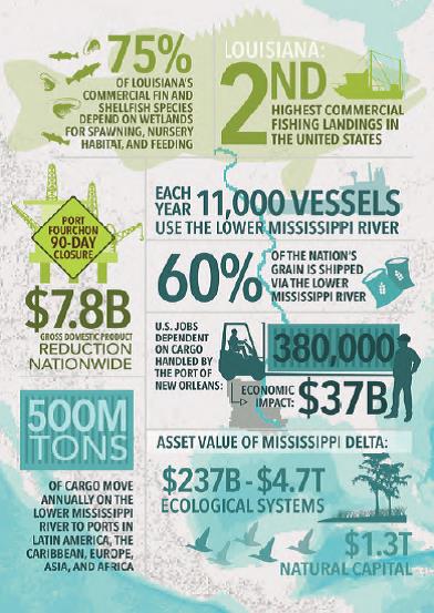
Louisiana has 5 of America’s top 15 ports.
Louisiana’s Mississippi River Delta is equivalent to $1.3 trillion of natural capital.
Louisiana habitat is responsible for the production of 21 percent of all commercial fisheries’ landings by weight in the lower 48 states.
Louisiana’s ports ship $21 billion annually in agricultural products.
Louisiana is home to approximately 75 percent of all commercially harvested fish species.
Oil and gas interests of the state — which account for nearly one-fifth of the nation’s refining capacity and around 125,000 miles of pipelines— are dependent on Louisiana’s coast and wetlands.
Louisiana’s vital pipeline infrastructure consists of nine interstate and four intrastate natural gas pipelines, which produce approximately $44 billion in annual fuel products for the nation.
Louisiana’s coast provides about 18% of the nation’s oil supply.
Louisiana’s Port Fourchon services 90% of the deep water oil and gas activity in the Gulf of Mexico.
Louisiana’s ports, which ship 60% of the nation’s grain and host the most tonnage in the Western Hemisphere, are also largely dependent on Louisiana’s coast.
The Mississippi Flyway passes directly over south Louisiana, and more than 3 million migratory waterfowl travel through or winter in Louisiana marshes. Coastal Louisiana also provides habitat for millions of neo-tropical migratory birds traversing the Gulf of Mexico.
CPRA Highlights from 2017 Master Plan and FY21 Annual Plan:
From Louisiana’s 2017 Coastal Master Plan
An additional 2,250 square miles lost by year 2067 if no additional action is taken.
$3.6 Billion in Louisiana business, residential, and infrastructure lost due to land loss.
An additional $138 Billion in Louisiana business, residential, and infrastructure assets are at risk due to increased storm damage in Louisiana tied directly to lack of action and protection.
$7.6 Billion in economic activity throughout the nation.
The CPRA has:
- Built or improved approximately 315 miles of levees
- Benefited over 46,058 acres of coastal habitat
- Secured approximately $21.4 billion in state and federal funding for protection and restoration projects
- Identified and used dozens of different federal, state, local and private funding sources for projects
- Moved over 150 projects into design and construction
- Constructed projects in 20 parishes
- Constructed 60 miles of barrier islands and berms